 When visiting top destinations in South America such as the Galápagos Islands or Machu Picchu, spectacular natural and cultural riches await visitors.
Machu Picchu („Old Summit“), Peru
Without having seen the Machu Picchu, you have not been to South America. At least that’s what many South Americans claim. Undoubtedly, the „old peak“, as Machu Picchu is called in Quechua, is the most impressive Inca ruin on the continent and the number one travel destination in South America. In the high season from late May to early September, up to 2,500 guests a day visit the mystical site, which has been a World Heritage Site since 1983.
Its unique location at 2,360 metres in the middle of the Andes alone is worth countless photo motifs. With a bit of luck, early risers can experience a fantastic sunrise over Machu Picchu and the surrounding mountains.
It was not until 1911 that the American Bingham accidentally discovered the jungle-covered settlement, which is not visible from any point of the valley, and later uncovered it. It became world famous when the National Geographic Society dedicated an entire issue to it in 1913.
But nobody knows who lived in Machu Picchu and why the settlement was abandoned. But it is certain that it was built in the middle of the 15th century, in the heyday of the Inca Empire. The districts that were strictly separated according to differences in status were connected by many stairs. To this day, in addition to around 3,000 steps, the outer walls of the residential buildings, some of which are multi-storey, have been preserved.
There are two ways to reach Machu Picchu: on foot in two to four days on the famous Inca Trail – by prior appointment – or by train from Cusco to Aguas Calientes, a small town near Machu Picchu. From there you can take the bus or walk for about two hours to the entrance.
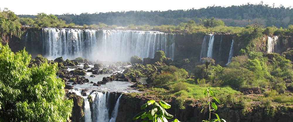
Iguaçu National Park, Brazil & Argentina
„Iguazú“ means „big water“ in the language of the Guaraní: The rushing of the 20 bigger and 255 smaller waterfalls in a 2.700 meters wide canyon can be heard almost everywhere in this beautiful tropical park. If you get closer to the waterfalls, a natural spectacle opens up to you that you will not forget for a long time.
The waterfalls are located in both the Argentinean National Park Iguazú and the Brazilian National Park Iguaçu, both of which are UNESCO World Heritage Sites. Although the majority of the falls are located in Argentina, the panoramic view from the Brazilian side is particularly impressive.
On three circular routes at different heights, you can get dangerously close to the waterfalls and already feel the cold breath of the spray. It is not seldom that you finish your photo shooting soaking wet. Especially the brave ones can get even more in touch with the bubbling water in a rubber boat, less brave ones take a small boat to the beautiful island of San Martin, which is located between the two main waterfalls.
The absolute highlight of the Iguazú Park is the Devil’s Throat (Spanish: „Garganta del Diablo“) – a u-shaped, 150 meter wide and 700 meter long gorge into which the thundering water pours. If one looks into the depth here, one feels as a human being very small.
But apart from these natural spectacles, the two parks are worth a visit in themselves. Here, where the last remains of the Atlantic rainforest are protected, exotic animals like the colourful toucan, cheeky coatis, curious monkeys and many vultures cavort. If you don’t want to walk anymore, just take the park’s own train and rest in one of the restaurants.
Islas Galápagos (Galápagos Islands), Ecuador
One should not expect a tropical paradise here, but a lot of adventure. Although there are also some nice white shell beaches in the Galapagos, the coast with its dark lava rocks looks rather rough. Reason: the archipelago in the Pacific Ocean belongs to a mountain range of volcanic origin that is mostly under water. The climate is also rather moderate despite the proximity of the equator, the sea water is relatively cool with 20 degrees Celsius.
But the stars of the island – the animal inhabitants – feel all the more comfortable here. Around 40 percent of the species are only native to the Galápagos Islands. Among the most prominent representatives are the famous Galápagos giant turtles, sea lizards, Galápagos land iguanas, lava lizards, Galápagos penguins, Galápagos sea lions, Galápagos sea bears, maned seals and brown pelicans.
The archipelago became world-famous when Charles Darwin visited it on his world trip in 1835 and found further inspiration for his theory of evolution. In 1978 UNESCO declared the archipelago a „World Heritage Site of Nature„. Now that tourism has become not only the number one source of income, but also the greatest threat to the fragile ecosystem and wildlife, the Ecuadorian government regulates tourism, air travel and settlement more strictly.
Lake Titicaca, Bolivia & Peru
Lake Titicaca has no equal: With an area of around 8,300 square kilometers – 15 times the size of Lake Constance – it is the largest lake in South America and, at 3,810 metres, the highest commercially navigable water body on earth. The first impression is overwhelming: with its clear blue water, the lake appears almost unreal in front of the snow-covered peaks of the Andes, almost kitschy like on a postcard.
The 36 islands are spread over the whole Lake Titicaca, which – according to popular belief – is the cradle of the Inca culture and became the most holy water of their empire. Some islands are closely connected to the Inca mythology like the Isla de la Luna (Moon Island) and the Isla del Sol (Sun Island).
At the bottom of the lake, it is said, lies the 2,000 kilogram gold chain of the Inca Huascar, which faithful Indians saved from the invaders from the sun temple Coricancha in Cusco. Marine researcher Jacques Cousteau tried to find this chain in the 1960s, but instead came across a three-colored frog measuring 60 centimeters, which probably never emerges from the water.
The floating reed islands of the Urus should not be missing on any sightseeing tour. The indigenous group built them to hide from the warlike Incas. If an attack threatened, the Urus loosened their anchorage and withdrew with the islands to the lake. Even today they still live very traditionally and do not want to resettle on the mainland. However, tourists are allowed to visit them on their wavering islands of totora reed and get an idea of their way of life.
Since half of Lake Titicaca is in Peru, Puno is the main starting point for excursions. In Peru’s „capital of folklore“, traditional dances such as the famous Devil’s Dance are performed at many major events, so that the waiting time until the next tour flies by.
Parque Nacional Torres del Paine (National Park), Chile
The Chilean National Park at the southern tip of the Andean chain could be a miniature version of Alaska: On only 181,000 hectares the same landscape forms as in the northernmost US state. Mountains up to 3,000 meters high, waterfalls, forests, fjords and huge lakes in all shades of blue and green form the backdrop for a grandiose natural spectacle.
A large part of the park is glaciated, the flora and fauna of the UNESCO protected biosphere reserve is rich in species. Its landmarks, the three needle-like high granite mountains Torres (towers) del Paine, appear to the visitor in nature even more impressive than on the photos.
But in order to really dive into the breathtaking nature, one should go on hiking tours of one or several days. The paths in the probably most beautiful hiking area of the world are well signposted and promise unique nature experiences. Where else can you see herds of guanaco roaming the grass steppe and the Andean condor hovering above you while „hiking“?
The easiest way to reach Torres del Paine is from the town of Puerto Natales, which is about 120 kilometres away – from there, buses run into the park several times a day. The best time to travel is between November and March, although the weather here is often unstable even in the Chilean summer. Visitors have to register and pay a national park fee when entering the park.
Amazon, Brazil
Piranhas, jaguars, caimans, alligators, tapirs, armadillos, river dolphins, anacondas, boa constrictor, parrots: The Amazon is home to countless species, some of which are not even classified. Because the dimensions of this area are enormous: the gigantic system of rivers and forests takes up half of Brazil and extends into the neighboring countries.
The port city of Manaus on the Rio Negro is the starting point for tours into the Amazon region. At the end of the 19th, beginning of the 20th century, the city boomed, as the region was for a long time the only supplier of rubber. Today, the capital of the state of Amazonas is mainly known for its theater „Teatro Amazonas“. Tourists also like to make a stop here because the „duty-free capital of South America“ has a lot of interesting shopping to offer.
To get to know the Amazon better, you should definitely spend several days by taking the boat on narrow rivers and across the wide river. There is a boat for every budget, but the most authentic way to get there is on one of the wooden ships, where passengers lie in hammocks on crowded middle decks, are condemned to sweet idleness and can watch the hustle and bustle on the water, in the harbors and jungle villages in peace and quiet. A special highlight in the evening: the spectacular sunsets and moonrises in this unique river landscape.
Rapa Nui (Easter Island), Chile
Didn’t we already ask ourselves as children what Easter Island has to do with Easter? And who are those grim stony fellows that are standing around all over the island? In order to find out, you should get on a plane in Santiago de Chile and investigate directly on the most remote inhabited island in the world.
The first thing you’ll find out: Its correct name is Rapa Nui, which in Polynesian dialect means „Big Island“. It only has something to do with Easter in the way that the Dutchman Jakob Roggeveen landed there with three ships on Easter Sunday 1722 and named the island after the day of discovery.
As far as the approximately 1,000 moais are concerned, no one has yet been able to completely unravel the mystery surrounding them. But one thing is certain: Whoever faces them for the first time is overwhelmed. The gigantic stone figures fit perfectly into the barren, grassy landscape and give it a touch of mysticism. The statues do not stand in isolation, but are part of a ceremonial complex as known from other parts of the South Pacific. In terms of size, however, the buildings on Rapa Nui are far larger than those on other sites in the South Pacific.
The moais, which are estimated to be 3,000 years old, were made from the grey rock of Rano Raraku. In the quarry of this volcano there are almost 400 half-finished statues, including a 21 meter long Moai still connected to the rock. The largest erected statue measures 9.8 meters, with the average moai being about four metres high and weighing about 12.5 tons.
The most beautifully situated place of worship on the island is the Ahu Nau Nau at Anakena Bay. With its white palm-fringed sandy beach, visitors now really feel like they are on a South Sea island. And in the evening, the little town of Hanga Roa serves a culinary specialty of the island: „curanto“ – a meat, potato and vegetable stew cooked in a hole in the ground.
Desierto de Atacama (Atacama Desert), Chile
There is no way around the Atacama Desert, even if the tourist place San Pedro is not exactly on the way from north to south Chile. In the popular but overpriced boom town, the masses push their way through the streets from late afternoon, swarm into restaurants and crowd into travel agencies to book even more excursions. But this should not detain anybody from a visit, as the desert with its salt lakes, geysers, colored rocks and oases is absolutely worth seeing and San Pedro at a height of 2.443 meters is the starting point for the tours.
One of the shorter trips leads to the salt lake Salar de Atacama of the size of Lake Constance. Snow-covered volcanoes like the 5,916 meter high Licancábur volcano on the border between Chile and Bolivia stand out from the deep blue sky and make the cameras click every second.
Another half-day excursion takes you to the low vegetation landscape of the Valle de Luna (Moon Valley) just outside San Pedro. Especially many groups of tourists come here in the evening to watch from a dune how the setting sun colours the cliffs reddish. To visit the Tatio Geysers, which are further away, one has to get up very early and dress warmly: Due to the morning activity of the volcanoes, the geysers steam most impressively shortly after sunrise. However, at an altitude of over 4,000 meters it also becomes sensitively fresh.
Salar de Uyuni (salt desert), Bolivia
With an area of over 10,000 square kilometers, the Salar de Uyuni is probably the largest salt lake on earth. Situated at an altitude of 3,653 meters, it is one of the most interesting landscapes of the „Altiplano“ – the drainless plateau between the high mountain ranges of the West and East Andean mountains. Of the estimated 10 billion tons of pure salt stored in the Salar de Uyuni, around 25,000 tons are mined by the local farmers with picks and shovels and transported to the cities.
Virtually no living creatures can survive in the huge salt desert. Only a few South American flamingo species breed in this inhospitable area. But there is one exception worth seeing: In the middle of the lake lies the island Incahuasi, which in Quechua means „house of the Inca“. Here, columnar cacti grow up to 20 metres high and some of them are more than 1,200 years old. An isolated group of Viscachas – rodents related to the chinchillas – also feel at home on the island, which towers 169 metres above the salt lake.
In Bolivia, the small town of Uyuni, located southwest of the salt lake, is the starting point for excursions to the Salar de Uyuni. Tours to the salt pan can also be booked from Chile, for example in combination with a visit to the Atacama Desert.
Los Lagos (Lake District), Chile
High mountains, green valleys, deep blue lakes – we are not talking about Upper Bavaria here, but about „Chilean Switzerland„. Domestic and foreign visitors rave about this unique landscape, which lies over 1,000 kilometers south of the capital Santiago. You can spend weeks in this area – going from lake to lake, visiting places shaped by German immigrants or discovering the beautiful national parks.
For example the „Parque Nacional Puyehue“: It was established to protect large areas of evergreen (cold) rainforest. In this most visited national park in Chile, nature lovers get their money’s worth: Against the backdrop of snow-covered volcanoes, they can hike along nature trails, climb mountains (for example, the Puyehue and Casablanca volcanoes), visit thermal springs, camp, ski in winter and take lots of pictures.
Rare animals such as pumas, dwarf deer and the condor live here, and unusual plants thrive, for example the Chilean eucryphia (Ulmo) with many trunks and white flowers, and the southern beech, which is reflected in the clear water of the lakes. Time should also be planned for the „7-Lakes-Route„: It leads through the most beautiful national parks of the Chilean and Argentinean lake region and can be explored by boat or rental car. The only risk factor here is the changeable weather.
If you are German and get homesick at home, you can make a detour to Valdivía or Puerto Montt, for example – cities that were strongly influenced by the German immigration flows in the 19th century. In the small village of Puerto Varas, which is picturesquely located at the Lago Llanquihue and offers a great view to the Volcán Osorno, names like „Ellenhaus“ or „Bäckerei Klein“ remind on the German settlement.
More top national parks
Colombia: Gorgeous National Park Los Nevados »
Chile: Insider tip Lauca National Park »
Insider tips: More beautiful national parks in South America »